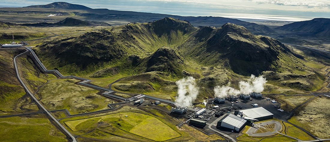
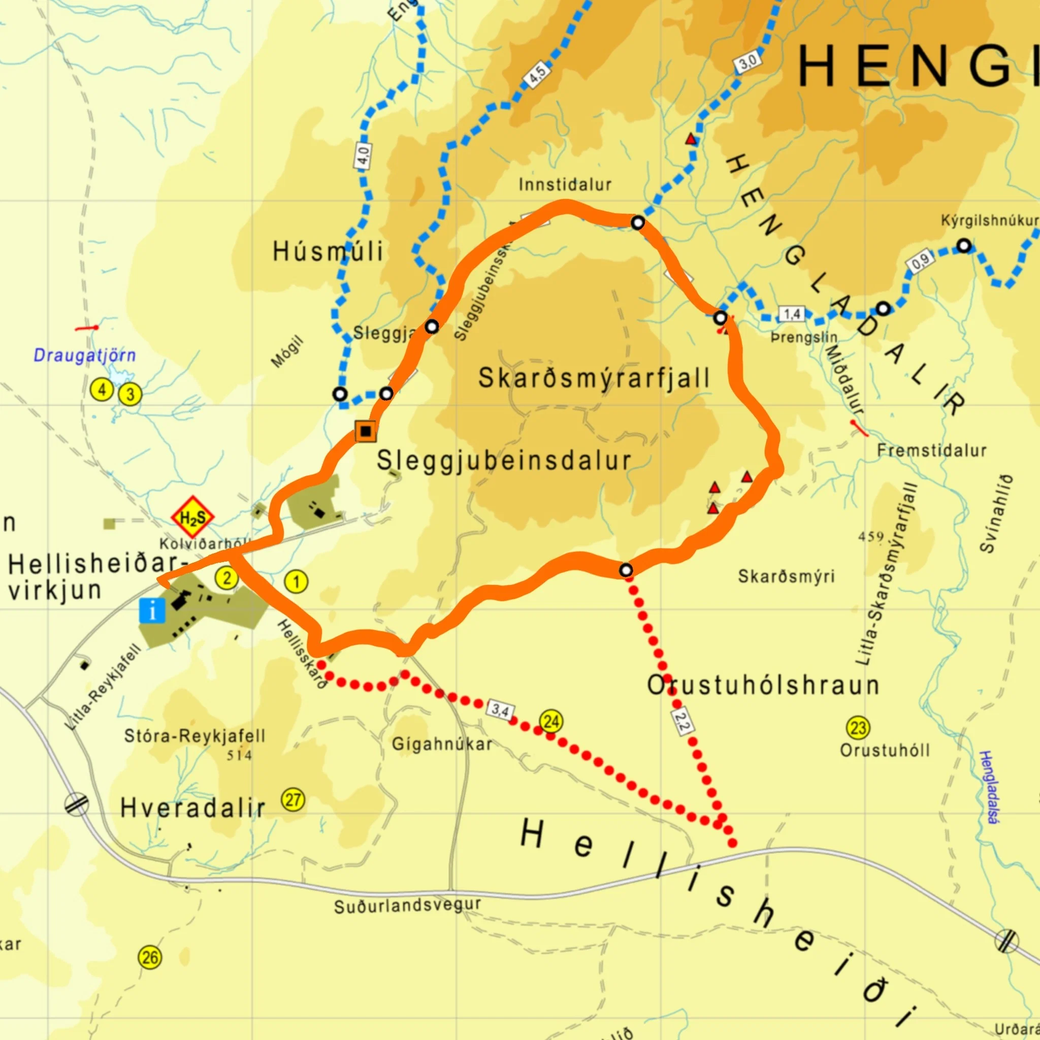
ON Power’s Geothermal Run
Hellisheiði Power Plant – Sleggjubeinsskarð – Innstidalur – Skarðsmýri – Hellisskarð – Hellisheiði Power Plant
Starting point: Geothermal Exhibition at the Hellisheiði Power Plant
Distance: 13 km
Total elevation gain: 334 m
Estimated walking time: 2.5-3 hours
Estimated running time: 1-2 hours
GPX file
Route description: The run starts on asphalt and the route heads into Sleggjubeinsdalur, where marked poles lead runners up Sleggjubeinsskarðið. From there, the route heads down into Innstadalur, through grassland, across streams and along trails. The marked route continues along Hengladalur, where the runners then leave the marked route and follow the trail from Miðdalur to Fremstadalur.
The route then follows the base of Skarðsmýrarfjall on a path called ‘milli hrauns og hlíðar.’ From there, once runners are on the asphalt, the route continues to Hellisskarð and down towards the Hellisheiði power plant.
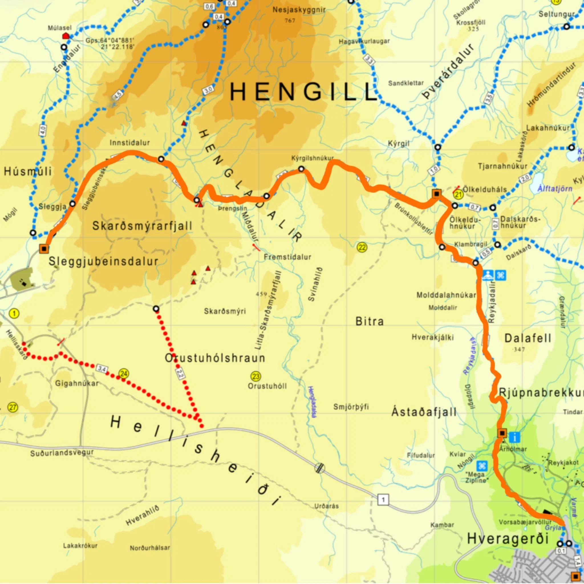
The Power of Well-Being
Sleggjubeinsdalur – Reykjadalur – Hveragerði
Starting point: Sleggjubeinsdalur
End point: Hveragerði
Distance: 19 km
Total elevation gain: 500 m
Estimated walking time: 4.5 hours
GPX file:
Route description: A refreshing hiking trail that starts in Sleggjubeinsdalur and ends in Hveragerði, roughly 19km in total. Remember to consider transportation issues, as the hike does not start and end in the same location. You can bathe in the streams in Reykjadalur on the way down and then end the journey with food and drinks in Hveragerði. A slightly more challenging hike, but as mentioned, ends in Hveragerði, where plenty of restaurants and shops are available.
The Top (of the World)
Sleggjubeinsdalur – Vörðuskeggi – Innstidalur – Sleggjubeinsdalur
Starting point: Sleggjubeinsdalur
Distance: 13.3 km
Total elevation gain: 705 m
Estimated walking time: 5-6 hours
GPX file:
Route description: A popular trail for good reason, but quite a challenging route. The trail starts at the parking lot in Sleggjubeinsdalur, near the Hellisheiði power plant. Walk up Sleggjubeinsskarð until you reach a crossroads that divides the path, both of which end at the summit of Vörðu-Skeggi. One path goes along the western slope of the pass, while the other goes into Innstadalur and from there, up to the summit. Here you can hike both clockwise or counterclockwise; it is more popular to go clockwise and end in Instadalur. The view increases in all directions as you gain elevation, and it is best from the western slopes of Hengill and from the summit of Vörðu-Skeggi.
The trail through Innstadalur can be wet well into the spring; if this is the case, turn around rather than cause damage to the trail. During the winter and early spring months, it is important to have appropriate winter mountaineering equipment like crampons and ice axes. At the top of the western slope of the mountain is a steep incline and a ravine where snow lingers for a long time, making this part of the route dangerous. As a result, there is a marked detour, Sleggjubeinsdalur’s winter/spring detour (Hjáleið Sleggjubeinsdalur vetur/vor), which also ends at the top.
The long walk
Sleggjubeinsdalur - Engidalur - Marardalur - Norðursyllur - Hagavíkurlaugar - Ölkelduháls - Dalskarð - Álútur - Dagmálafell – Úlfljótsvatn
Starting point: Sleggjubeinsdalur
Distance: 33 km
Total elevation gain: 1,121 m
Estimated walking time: 10-13 hours
GPX file:
Route description: This is a beautiful and challenging day trip, perfect for those who want to start in the morning and walk until the evening, enjoying the charming Hengill area. The walk begins at Sleggjubeinsskarð, where the path follows a marked trail into the lush Innstadalur valley and continues east up to Ölkelduháls, where geothermal energy is evident with steam rising from the ground alongside hot springs and pools. From there, the walk is between Ölkelduhnúkur and Dalskarðshnúkur, with views down to Reykjadalur. The hot stream in Reykjadalur is visible and here you could head down and bathe in the river (útúrdúr).
The path itself runs along the slope above Reykjadalur, up Dalskarð, where the Dalasel hut once stood. The trail is through the pass and from there down to Grændalur. The trail crosses the valley towards the mountain Álút, where the view is good. From Álút, the hike descends along the Efjumýrar ridge, up to Dagmálavell and from there down the green slopes towards Úlfljótsvatn. Note that the last section is wet in the spring.
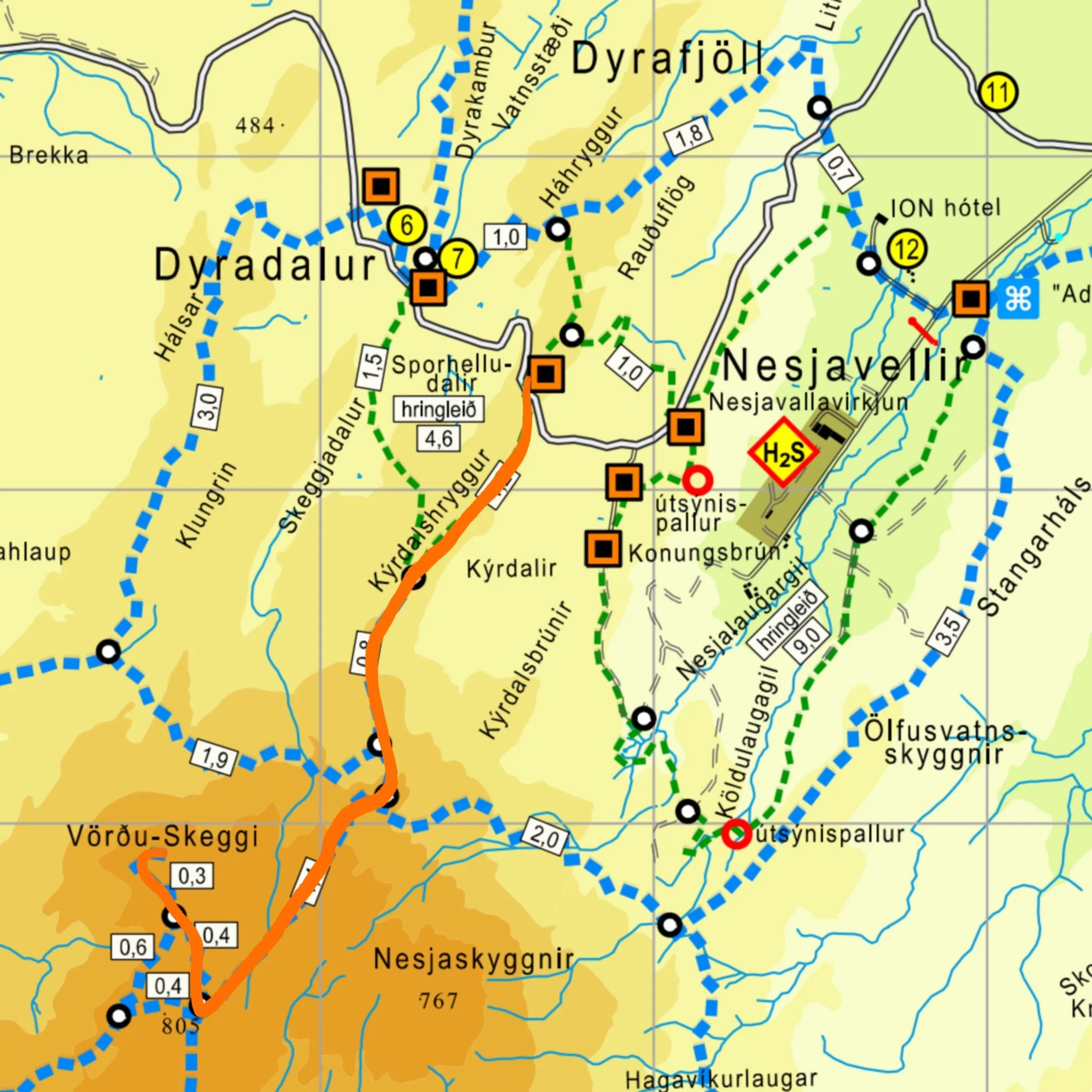
The Shortest Route up to Vörðu-Skeggi
Containers on Háhrygg - Kýrdalshryggur - Vörðu-Skeggi and same way back
Starting point: The water tanks at Nesjavellir
Distance: 9.5 km
Total elevation gain: 469 m
Estimated walking time: 3-4 hours
GPX file:
Route description: The shortest route up to Vörðu-Skeggi and the route with the least elevation to the top, as it starts at a considerable height. It is a fascinating hike and begins at Nessjavellir, by two water tanks on Háhrygg. From there, the hike is towards Hengill, following Kýrdalshrygg. The path runs along impressive rock formations and the view over Þingvallavatn is spectacular. The climb starts vigorously after Kýrdalshrygg, but as mentioned before, the hiker avoids a considerable elevation from the start point.
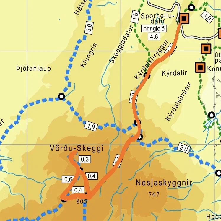
If time permits, we recommend an excursion on the way up.
Instead of taking the shortest route up, you can follow the so-called winter bypass, marked on the road sign as Hjáleið Sleggjubeinsdalur vetur/vor.
Attention: it is easy to miss the turn onto this trail. The trail is quite steep in parts and sometimes difficult to see between posts due to the steepness.
This is a fun addition for those who are confident. A hiker enters the trail that has been hiked from the Hellisheiði power plant to the top. The trail goes through a snow ravine and is not suitable during the winter or spring, or when there is a lot of snow on the
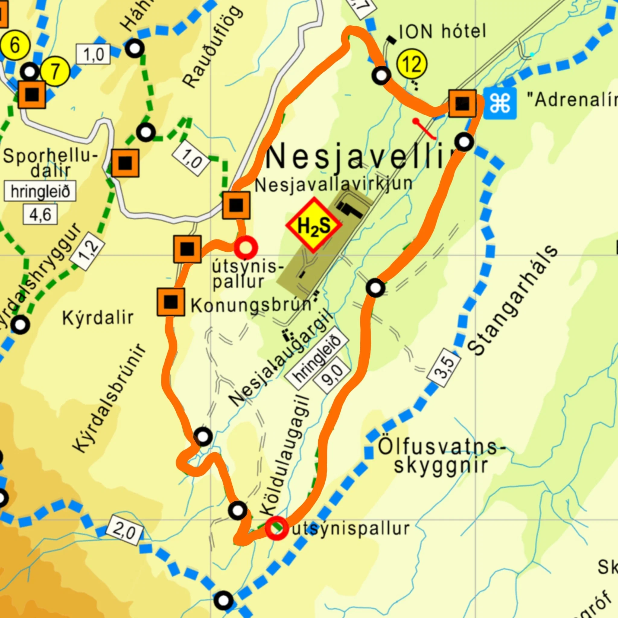
The Educational Circle
ION hótel - Konungsbrún - Nesjalaugar - Köldulaugagil – Adrenalin park
Distance: Almost 9km
Total elevation gain: 251 m
Estimated walking time: 2.5-3 hours
GPX file:
Route description: The best maintained hiking trail in the Hengill area showcases the diverse landscape of Nesjavellir. The walk crosses lava fields and streams alongside heather-covered slopes, into a ravine and amidst a beautiful geothermal landscape.
On the slopes of Nesjalaugi and at Köldulaugagil, there is bubbling geothermal activity and the spectrum of colors that comes with it leaves its mark on the area. It is possible to start the hike at several different locations, but the slope above the ION Hotel is steeper on the way down, so we suggest walking from the Adrenalin Adventure Park to the ION Hotel and from there up to Konungsbrún. There, hikers are greeted by a magnificent view.